
多维数据展示
数鹏通(LinkCM)科技“G-MDD 多维数据展示”,提供强大的多维海量数据处理能力,地理信息引擎支持各种类型的POI兴趣点数据,包括医院、学校、旅游景点等各类数据;系统支持第三方的地图服务、数据服务和网络分析服务。
LinkCM “G-MDD GIS Muti-Data Display”, provide powerful multi-dimensional mass data processing, geographic information engine supports various types of POI data, including hospitals, schools, tourist attractions, such as various types of data; system also support third-party map service, data service and network analysis services.

叠加分析研判
数鹏通(LinkCM)科技“G-OVA 叠加分析研判”,提供强大的多图层叠加分析能力,地理信息引擎支持多图层的空间数据进行叠加分析,包括卫星云图、雷达回波图、台风等各类数据。
LinkCM “G-OVA GIS Overlay Analysis”, provide powerful multi layer overlay analysis ability and geographic information engine supports multiple layers of spatial data overlay analysis is conducted, including satellite, radar, typhoons and other types of data.
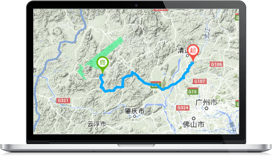
智能道路导航
数鹏通(LinkCM)科技“G-IRN 智能道路导航”,通过大数据技术高效分析百万级以上道路,实现快速定位,提供智能避灾导航,结合实时灾情状况,通过人工智能分析,提供多条备选线路选择。
LinkCM “G-IRN Intelligent road navigation”, analysis million level of the road, to achieve fast positioning, provide intelligent disaster avoidance navigation, combined with real-time disaster situation, through artificial intelligence analysis, offer a choice of multiple alternative routes.
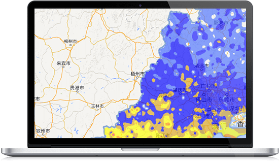
色斑图滤波分析
数鹏通(LinkCM)科技“G-GPE 图形处理引擎”,提供强大的图形处理能力,同时结合空间分析能力,通过大数据并行计算的高速实时滤波,实现影响预报及精准靶向预警。
LinkCM “G-GPE Graphic Processing Engine”, provides powerful graphics processing, space analysis and real-time filtering capabilities, achieve impact-based forecasting and precision targeting early warning.
二三维一体化
数鹏通(LinkCM)科技“G-3DI 二三维一体化”,系统支持卫星图、地形图、业务图等二维地图,同时支持高仿真三维地图,实现虚拟现实动态展示。
LinkCM “G-3DI GIS Two & Three Dimensional Integration”, the system supports satellite maps, topographic maps, business plans and other 2D maps, while supporting high simulation 3D map, to achieve dynamic display of virtual reality.


多数据源接入
数鹏通(LinkCM)科技“G-MSA 多数据源接入”,提供强大的多数据源接入能力,地理信息引擎支持各种类型的空间数据,包括报文、XML、SHP等各类数据格式;系统支持第三方的地图服务、数据服务和网络分析服务。
LinkCM “G-MSA GIS Muti-Data Source Access”, provide powerful multi data source access ability, GIS engine supports various types of spatial data, including messages, XML, SHP and other types of data format; support third-party map service system, data service and network analysis service.